This amazing drone video details what it’s like to summit Mount Everest

In just 4 minutes, you can see all the majesty of Everest

Mount Everest
Martin Jernberg / Unsplash

Have you ever dreamed of climbing Mount Everest? Many aspire to conquer the heights, but very few succeed. It’s definitely not for the faint of heart, but if you’re curious about the journey, you can now view the entire route in a 4-minute clip filmed by Chinese drone company, DJI.

DJI films jaw-dropping video of Mount Everest
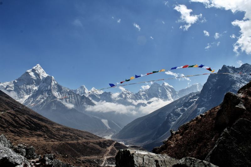
Prayer flags in front of Mount Everest.
Ananya Bilimale / Unsplash

Composed of four different video clips seamlessly edited together, DJI captures the stunning nature of Mount Everest for the world to experience in a new way. For anyone interested in seeing the world’s highest peak from a perspective that was once unimaginable, this new video offers an unforgettable experience. Check it out!

29,000 Feet Up Mount Everest with DJI Mavic 3 Pro

The journey begins from the Base Camp at 17,598 feet and soars all the way to the summit at 29,032 feet. This stunning footage was filmed using the DJI Mavic 3 Pro drone, which you can pick up at your local electronics store.

Needless to say, these drones can stand up to all kinds of harsh temperatures and weather, which is why they are perfect for the job. To make it up Mount Everest, these drones have to be able to handle extreme cold, high winds, thin air, snow, ice, and obstacles.

But that’s not all DJI is doing around the world’s greatest peak. Earlier this spring, the company tested its cargo drone, the FlyCart 30, at the Everest Base Camp. After loading it up with two oxygen tanks, they worked with Nepali officials to pilot the FlyCart 30 over the notoriously challenging Khumbu Icefall up to Camp I. The delivery was successful.

Officials and experts now see significant potential in using drones like the FlyCart 30 for logistical support on Everest. These drones could someday ferry essential gear up the mountain and transport trash back down, making expeditions safer and more efficient.

The cost of climbing Mount Everest has significantly increased in recent years, primarily to enhance safety measures for climbers. These expenses cover better equipment, experienced guides, improved communication systems, and more efficient waste management practices — all essential to mitigate the inherent risks of such a perilous ascent. Drones could also aid in emergency situations by delivering vital supplies swiftly and safely, which could potentially lower the overall costs while increasing the safety. It’s all in the works!

For now, however, DJI’s drones are primarily being used to capture vertigo-inducing videos that provide viewers an unprecedented look at the grandeur of Everest. By offering a glimpse into the majestic landscapes that few will ever physically experience, these aerial clips are sure to inspire people to reach new heights, both in their own neighborhoods and across the world.

Sarah Joseph
Sarah is a lover of all things outdoors. With a bright sense of adventure and a heart for the mountains, she is always…
Cost to climb Mount Everest is skyrocketing because people keep dying
The per-person fee is what a whole expedition cost in 2015
A hiker looks out over Mount Everest.

There are too many dead bodies on Mount Everest; that's the message from the Department of Tourism in Nepal. It might sound morbid, but in the several weeks it would take you to climb to the highest point on Earth, you'll see plenty of those who were once ambitious climbers but succumbed to the challenge. There are so many bodies littering Mount Everest that it's commonplace to use them as markers or signposts along the way.

If you're one of the many would-be conquerors of this mighty mountain, none of this will shock you. But what might come as a shock is the knowledge that the endeavor — which already sets climbers back around $50,000 — is about to get even more expensive. But why is Nepal's tourist board increasing the cost to reach the top of the world, and what's it got to do with those who lost their lives trying to conquer what many consider the ultimate bucket list challenge?

Read more
What It’s Like Hiking the Knife Edge Trail to the Highest Peak in Maine
hiking the knife edge trail

Mt. Katahdin in Maine, USA Image used with permission by copyright holder

One of New England’s grandest nature reserves, Baxter State Park spreads across some 210,000 acres in northern Maine. Dense forests, mirror-like lakes, and craggy mountain peaks form the backdrop to this state’s best-loved wilderness escape. There’s great wildlife watching (1,300-pound moose are plentiful in late spring and autumn), idyllic paddles on pristine ponds, and back-country campsites where you can drift off to sleep while listening to the haunting calls of a loon echoing across the waterways.

Read more
How Mount Everest Grew Even Taller in 2020
hikers climbing Mount Everest

Mount Everest, the tallest mountain in the world, got a little bit taller in 2020. The mountain, called Sagarmatha in Nepal and Chomolungma in Tibet, is now officially 29,031.69 feet (8848.86 meters) tall according to a joint survey done by Nepal and China. The new findings were announced December 8, 2020 in Kathmandu, Nepal’s capital city and the starting point to Everest for many climbers and explorers.
Why Measure a Mountain Again?
You might think that mountains are pretty stable creatures, just standing there all stoic for millennia. They actually move regularly for various reasons.

Everest and the other Himalayan mountains sit on the intersection of the Indian and Eurasian tectonic plates. The plates are crashing into each other (very slowly) and pushing the tallest mountains in the world upwards at about ⅓ of an inch per year.
Related Guides

Read more