
Death Valley National Park is infamously known as big, barren, and foreboding. So why is it named one of the best national parks to visit in winter, attracting over 1 million annual visitors? The answer is in this park’s sheer variety of natural landmarks. One moment, you’re standing on a mile-long salt flat. Next, you’re admiring the rainbow-colored badlands, and by sunset, you’re trekking the dunes — all within the same park.
Have I piqued your interest? I hope so. Death Valley rivals Yosemite as one of California’s most ecologically diverse natural landmarks, and it deserves a visit. But what formations are most worth your time, especially if you only have one day to explore? Let me suggest a few must-see sights based on my most recent visit and a primer on the park’s history and geography.
Death Valley National Park’s history, climate, and key facts
Death Valley was established as a national park in 1994 and sits east of the Sierra Mountains at the border of California and Nevada. It’s the largest national park in the contiguous United States, covering a staggering 3.4 million acres of land. Driving across the park takes about 2.5 to 3 hours on California Highway 190. But enjoying detours and seeing the park’s main attractions can take a full day or two at a minimum.
The land is historically inhabited by the Timbisha Shoshone tribe, which currently collaborates with the park to ensure its preservation. Westerners first arrived in the mid-1800s when the Death Valley ’49ers sought a shortcut to the California gold fields. They deemed this section of the Mojave Desert a “death valley” after facing hardships and losing a pioneer during their grueling two-month journey.
And yes, conditions are harsh and hot—so hot that it holds the record for the warmest air temperature ever documented. Highs reach a scorching 120 degrees Fahrenheit during summer but sit at a more favorable 66 degrees Fahrenheit in winter months. As a result, winter months are the most popular in the park, but don’t count on cool weather—I can attest that it was 89 degrees when I visited in February.
With all the heat and less than two inches of rain annually, you’d think there isn’t much here to explore. But Death Valley surprises its visitors with its unique formations and stunning landscapes, which make visitors feel like they’re on another planet—although they’re simply looking millions of years back geo-historically.
Here are a few things to keep in mind when you plan a visit to the park:
- Watch the weather and dress accordingly, making sure you carry more water than you need, especially if you’re planning a more extensive Death Valley hiking trip.
- Developed, primitive, and private campsites are available in the park, but Death Valley camping may require permits and reservations, especially for higher-elevation campgrounds.
- Two park lodges and private lodging are available
- Check the NPS calendar for ranger-led hikes and other special events.
- The park costs $30 per vehicle, but consider purchasing an $80 America the Beautiful Annual Pass, which provides access to every national park in the U.S.
- Visit the Furnace Creek Visitor Center for updates on current closures and road conditions and to ask any additional questions. You can also refill your water bottles here.
Now, let’s jump into the must-see attractions that make Death Valley one of the most unique and diverse national parks in the United States.
Visit Badwater Basin, the lowest point in North America
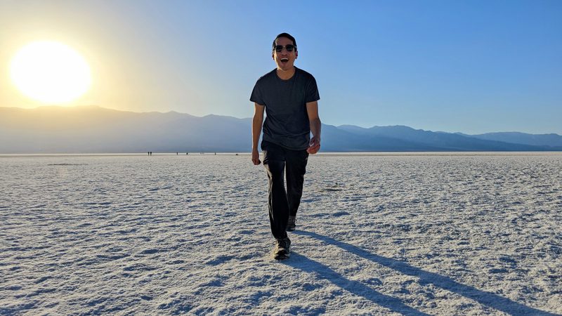
The Badwater Basin is a vast remnant of an ancient lake that sits 282 feet below sea level, the lowest spot outdoor enthusiasts can stand in the United States. Temperatures are very hot down here, and there is no shade, so it’s best to visit earlier or later in the day. I thankfully experienced the Basin at sunset, which cast a pink tranquil hue on the white salt and nearby mountains.
Miles of shimmering salt crust line the lake’s floor, and visitors can walk miles out on the polygonal flats for an otherworldly experience unique to Death Valley.
Don’t forget to look for the “Sea Level” sign on the nearby cliffside to gauge how low you’re standing. Badwater Basin occasionally floods after rare heavy rains, and if you’re lucky, you might even kayak across its temporary lake.
Explore the warm landscapes of Golden Canyon
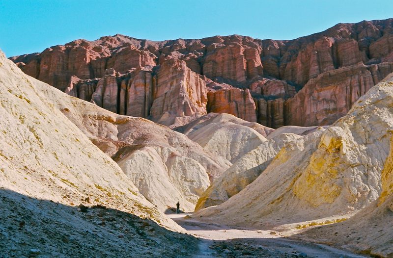
Welcome to Death Valley’s natural cathedral, featuring views of the Red Cathedral formation. This section of the park is home to its most popular hike, a 2-mile moderate trek that balances scrambling with serene canyon vistas.
This location is famous for being a filming site for Star Wars Episode VI, Return of the Jedi. Like the famous interstellar cast, you’ll explore the twists and turns of the rock formations, with dozens of narrow passages that allow for more challenging and secluded hikes.
Take in the sweeping views at Zabriskie Point
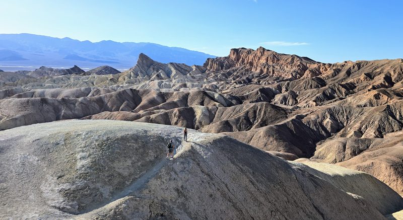
Zabriskie Point boasts one of the best views in the entire park. It requires only a short 0.3-mile out-and-back hike to enjoy panoramic views of ancient golden badlands. This location is best enjoyed at sunrise or sunset when the warm hues ignite the hillsides and badlands.
From this exact point, you can hop on the Golden Canyon, Red Cathedral, and Badlands Loop trails to more deeply immerse yourself in the formations and experience fewer crowds.
Drive through Artist’s Palette for full-spectrum colors
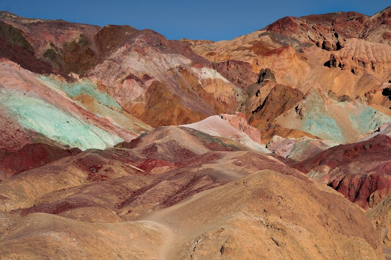
Artists Palette is a 30-minute scenic drive that isn’t to be missed and is perfect for those opting for scenic drives over hikes. The narrow passage is one-way and winding, so larger vehicles such as RVs and trailers are prohibited.
You’ll pass through various mineral-stained hills, with colors ranging from green to purple to pink. These vivid hues result from oxidized volcanic ash deposits that have been weathered over millions of years yet look like contemporary artists painted them.
I visited this destination later in the day, and due to the narrow channels, the rocks were covered in shadows, which meant duller colors. So, if possible, I recommend you take this drive midday because that’s when the sun is highest and can illuminate the colors most brilliantly.
See the Mesquite Flat Sand Dunes at sunrise or sunset
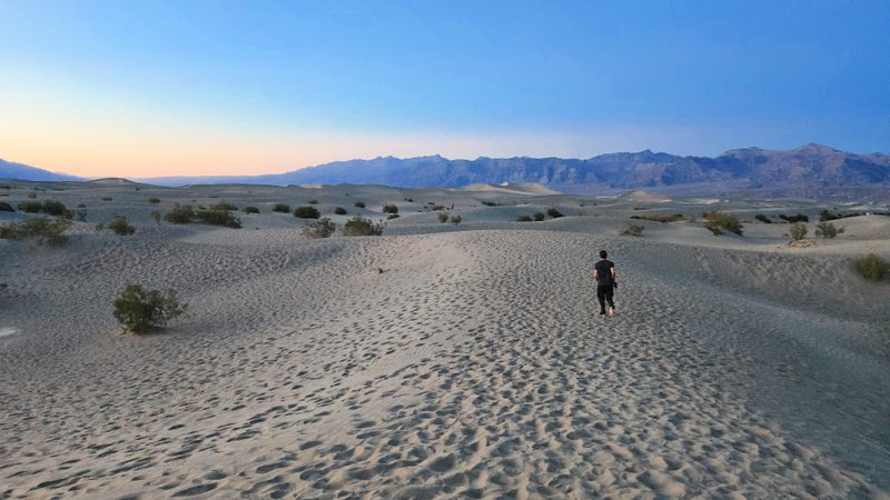
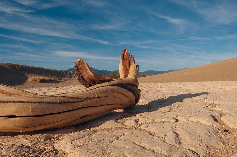
What would a Death Valley National Park guide be without a sandy desert landscape with rolling dunes? The Mesquite Flat Sand Dunes are the most accessible in the park, dotted with petrified wood and surrounded by towering mountains.
You can hike the dunes, which reach 100 feet, keeping an eye out for tracks from kanga rats and coyotes—signs of life in the seemingly barren landscape. When I visited during sunset (a magical time to watch the hues and shadows shift on the sand), I noticed dozens of people setting up for the real show—the night stars.
As an International Dark-Sky Certified park, this and many other locations are some of the best stargazing sites on the planet, so spend the night if there’s time in your schedule.


