
Peru’s New Yellowstone-Sized National Park Will Protect 2 Million Acres of Rainforest

It’s hardly news to say the Amazon rainforest is in peril and has been for more than two decades. Illegal mining and logging operations continue to decimate large swaths of the rainforest at an unimaginable pace. Thankfully, more and more South American countries are motivated and, more importantly, able to do something about it. In January 2018, the Peruvian government announced the creation of a new national park to safeguard more than two million acres of its own endangered land.

The Yaguas National Park is located near Peru’s border with Colombia in the northern region of Loreto. Its boundaries encompass a land mass roughly the size of Yellowstone National Park but with more than 10 times the diversity of flora and fauna. This is due in large part to the Putumayo  River,  an Amazon River tributary that runs through the heart of the park.

amazon rainforest yaguas national park fish
Image courtesy of Andes Amazon Fund Image courtesy of Andes Amazon Fund

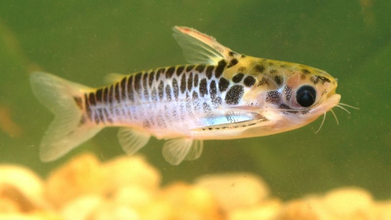
From a wildlife perspective, it’s a rich, varied, and critical ecosystem that’s home to more than 3,000 plant species, 160 species of mammals (like manatees and the Amazonian river dolphin), and 500 species of birds. Perhaps most importantly, it’s a vital piece of the country’s marine ecosystem with approximately 550 fish species that represent a full two-thirds of Peru’s freshwater fish diversity, which is among the richest assemblages of freshwater fish on the planet.

The advent of the automobile and subsequent boom in demand for rubber are arguably more responsible for the destruction of Amazon Rainforest land than any human act in history. The park’s creation is a long time coming, and has consequently been applauded by some of the world’s most active and well-respected environmental group. The South American-based Andes Amazon Fund has already pledged $1 million toward the park’s implementation.

Beyond the environmental damage, however, there’s been a very real human toll related to the rainforest’s decline. Some 29 communities — including 1,100 people from the Tikuna, Kichwa, Ocaina, Mürui, Bora, and Yagua tribes — call the area home. These are direct descendants of the area’s native people who rely on the land in general, and the endemic fish population in particular, to survive. For millennia, the area has been sacred land to their ancestors.

Alongside Chile and Argentina, Peru has long boasted one of the most diverse national park systems in the world. The creation of Yaguas National Park further cements their commitment to preserving the country’s most important and endangered lands.

Feature image courtesy of Andes Amazon Fund.

Mike Richard
Mike Richard has traveled the world since 2008. He's kayaked in Antarctica, tracked endangered African wild dogs in South…
Ditch the GPS: How to navigate using a map and compass
Don't worry, it's really not that difficult to find your way or location the old-school way
Fingers holding a map and compass in the outdoors

GPS devices and GPS apps for your phone and even navigation watches with GPX files are nearly foolproof today. But what about when you run out of battery or your waterproof device isn't as waterproof as you had hoped? Even worse, what if you spend your entire trip with your head buried in your GPS without taking the time to get to know your surroundings?

Here at The Manual, our number-one backpacking essential for every outdoor adventure is the humble map and compass. It's no use just buying these items and stuffing them into your backpack. First, you need to learn how to read a topographic map and know what all the twisting bits do and what the numbers mean on your compass. It can all look quite confusing, so we're going to demystify the art of how to navigate using a map and compass and let you go old school, ditch the GPS, and get to know your surroundings intimately.
Know the parts of the compass

Read more
A beginner’s guide on how to read a topographic map
Learn how to read and navigate with a topographical map from an expert
Reading a topographic map

Before you’ve packed your bags and before you’ve gassed up the wagon, there’s the little issue of figuring out where you’re actually going to go and -- more importantly, if you're going to be outdoors -- the type of terrain that's there.

One of the best ways to do that is to peruse a map of the region that goes a little further than just showing you a layout of the park. A topographic map introduces you to the peaks and valleys and gives you an understanding of how difficult the terrain might be in the area where you’re headed. It was originally developed as a way to depict counties and cities before the U.S. military used it in World War I.
Where to begin

Read more
These are the essential outdoor knots every outdoorsman should know
A well-versed arsenal of knots is a must-have for any outdoorsman
A reef knot is tied against a tree

There's almost no end to what you can achieve armed with a length of rope and an arsenal of outdoor knots to tie it together. If heading into the backcountry, you should always be prepared for survival. While part of that is carrying the right gear, you must know how to use it effectively. You wouldn't take your woodcutting axe without giving it a few practice swings at home, so why would you expect to tie the right knot without practice?

There is an adage among those who don't know what to do with rope: if you can't tie knots, tie lots. If you don't know what you're doing, keep tying until your rope feels secure. It works, sometimes. But in a significant way, these people are missing out. Knots, like backcountry navigation skills or making a fire, are part of being an outdoorsman. Outdoor knots come in different shapes and perform various tasks; some are quick, some secure, and others are designed to be untied quickly. These eight are the essential outdoor knots to learn first, so grab a rope and upskill your outdoor self.
Bowline knot

Read more