One of New England’s grandest nature reserves, Baxter State Park spreads across some 210,000 acres in northern Maine. Dense forests, mirror-like lakes, and craggy mountain peaks form the backdrop to this state’s best-loved wilderness escape. There’s great wildlife watching (1,300-pound moose are plentiful in late spring and autumn), idyllic paddles on pristine ponds, and back-country campsites where you can drift off to sleep while listening to the haunting calls of a loon echoing across the waterways.
Most people come here to hike, and with around 215 miles of trails, the options are dizzying. But for the diehard, one place stands out above all others: the rocky summit of Mount Katahdin. At 5,267 feet, the (nearly) mile-high peak is the highest point not only in the park but in the entire state. Appalachian Trail thru-hikers became well acquainted with this tough climb, as the 2,190-mile long-distance trek ends (rather sadistically if you ask me) atop this massif, which in the indigenous Abenaki language means “greatest mountain.”
Related Guides
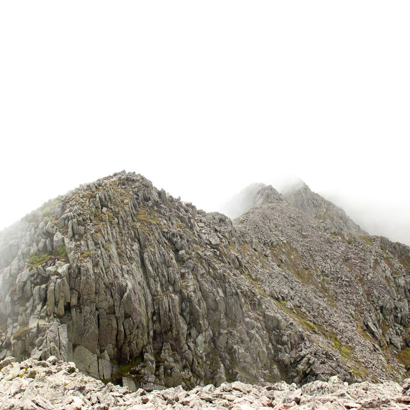
There are various trails leading up Mount Katahdin, and they’re all rated difficult. The most dramatic ascent is via a 1.1-mile corridor known as the Knife Edge Trail. True to name, this narrow traverse has steep drop-offs on both sides. It’s also a fully exposed climb in parts, where you’ll be scrambling up and down rocks while making sure not to lose your footing. Those with any fear of heights are strongly discouraged from going this route.
When I first learned about the Knife Edge Trail, my initial thought was, “that’s not for me.” I’m an avid hiker and traveler, who’s been lucky to trek through some rewarding, mildly challenging locations around the globe — like the Cordillera Blanca in Peru, the Spanish Pyrenees, and the Atlas Mountains in Morocco. But I’m rather easily deterred by warnings about deadly falls, lightning strikes, and undefined tragic accidents (often caused by rapidly deteriorating weather conditions) that have marred dozens of ascents up Mount Katahdin, especially along the Knife Edge. Deaths, though rare, still occur on the mountain. In October 2020, two fatal accidents occurred within a week of one other.
And yet, the more I learned about Katahdin, the more I was drawn to this mountain. After committing to a road trip in Maine, I placed the climb at the top of my itinerary. The weather in this part of the state is notoriously fickle, so it helps to be flexible in your itinerary. When the threat of heavy rains or strong winds arise, park rangers will strongly advise against taking the trails up the mountain (Baxter stops short of closing the trails altogether, leaving the responsibility in the hiker’s hands). I was traveling along the coast, watching the weather and looking for the ideal time to make my break for the north. When the rains finally subsided, I hopped in the car and made the two-and-a-half-hour drive north from Bar Harbor.
Before entering the park, I stopped in Millinocket, a former mill town that serves as the nearest gateway to Baxter — at least for those coming from the south. I topped up my diminishing supply of provisions (the park maintains no restaurants or supply stores inside the park) and stopped for a meal at the Appalachian Trail Cafe, which is plastered with notes left behind by thru-hikers over the years. Most importantly, I visited the park headquarters, where I purchased a decent map and got a last-minute insight into the climb I was determined to make by the following morning. I stayed the night at the Appalachian Trail Lodge, which this late in the season was packed with hikers taking a break from trail life before making the final break to the finish.
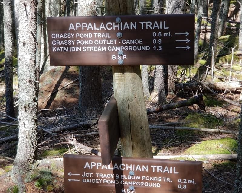
The next morning I rose before dawn and made the half-hour drive into the park, via the Togue Pond Gatehouse. Baxter has very strict rules, and if you haven’t booked an overnight camping spot or booked a day-use reservation in advance, you’ll have to get there early to snag one of the available last-minute parking spots near the trailheads. Being a last-minute traveler (and not wanting to waste time if the weather wasn’t cooperating), I hadn’t reserved ahead. However, coming this late in the season (it was early October) and on a weekday no less, I knew there would be spots available. Nevertheless, I got there when the gates opened at 6 a.m. — both to ensure that I wouldn’t be denied access to the park and to hit the trail early (a very long day awaited).
I paid the admission fee and bumped along the park’s dirt roads (Baxter intentionally leaves them unpaved) en route to the trailhead near the Roaring Brook Campground. I decided I’d set up camp later that night, and was eager to get underway. At the gatehouse near the parking lot, I checked in with the ranger, who confirmed that the trail was still ice-free and that the weather forecast looked clear for the day. Scrawling your name and destination in the logbook is your last interaction with civilization. A handful of hikers require rescue services every year, so it’s one vital piece of info that can make all the difference if things go south while you’re out on an exposed ridge.
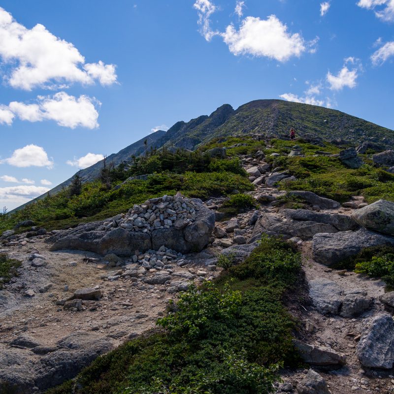
I started along the Helon Taylor Trail, which runs for 2.8 miles from Roaring Brook up to Pamola Peak at 4,919 feet. The first part of the walk was a steady uphill through sun-dappled forest, over slick-wet roots, across a trickling stream (the last water source), and alongside moss-covered boulders edging the trail. It took me around two-and-a-half hours to climb some 3,400 vertical feet. Once I left the tree line behind, the climb got considerably steeper. Sometimes I needed to use both hands to pull myself up and over four-foot high boulders. The views grew more dramatic until at last, I reached the battered wooden sign posted atop Pamola Peak. The view from here was staggering — or in places at least. Clouds had swept into the east while I stood surveying Hamlin Ridge, and completely obscured the ascent I’d just made.
Read more: Dispersed Camping Guide
The sign also indicated the direction toward the Knife Edge. Written below the arrow was “Do not hike this trail in bad weather.” One look at the traverse, which lay spread out before me, was enough to deter me from continuing — bad weather or not. I tried to catch my breath, and took a sip of water, contemplating the sharp ridgeline, which looked impossibly narrow from this angle. It didn’t quite seem possible that a human could walk along that without falling off. And yet, lots of people have done this, I told myself. Though the clouds were beneath me, the sun was on my face, and the wind was low. Conditions were ideal to continue onward, so I steeled myself and continued walking.
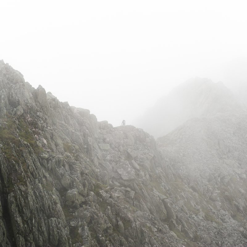
This part of the trek is just over a mile long, but it took me around 90 minutes to complete. It was also the most mentally challenging hike I’ve ever undertaken. I started off at a normal walking pace but quickly had to scramble up a rocky incline, bouldering style, using both hands to move myself up the slope. At the top of one rise, I’d then have to descend quite steeply and would move gingerly on all fours, trying not to look at the steep drop just inches beyond my reach. There were moments of pure, debilitating fear, where I had to talk myself down (or onward rather; down is not a direction I wished to consider). I learned later that this part of the trail is called Chimney Notch, requiring you to make a steep 100-foot descent, then ascend another 100 feet up the other side. It can be particularly perilous when other hikers are around, with the danger of falling rocks dislodged by hikers climbing up above you.
Arrows painted in blue guided me along, and I was grateful for these — I stuck closely to the rocks nearest the marks (at times, this was the only place I could traverse), doing my best to keep fear at bay. Another section of the Knife Edge followed along a narrow exposed ledge, with a sheer drop off several thousand feet into the valley below. I took it slow, leaning into the rock face, and placing my hands and feet carefully at every step of the way. Eventually, the jagged trail along the Knife Edge widened, and I realized I’d made it. I’ve never felt such relief to complete one section of a hike.
That day, I wasn’t the only one celebrating when I laid eyes on the signboard that announced “Katahdin. Baxter Peak. Northern Terminus of the Appalachian Trail.” It also listed distances to various onward trails, as well as “Springer Mountain, Georgia, via the AT 2,189.1 miles.” A disparate group of thru-hikers had just completed the monumental months-long hike that day. (If you want to run into AT hikers, you’ll likely see them coming through every day from September through October.) I chatted with some of them, congratulating their incredible achievement, then began the return journey. I came down the mountain via the Saddle Trail and Chimney Pond Trail, enjoying the views while not trying to lose my balance on the sections that were steep, but lacking the terror-inducing power of the Knife Edge.
All in all, the hike took a little over eight hours to complete (the park recommends giving yourself up to 12 hours from start to finish, so I made decent time). Dusk was already arriving when I made it back to my car. Though exhausted, I needed to find a campsite and set up for the night. I was too tired to make a fire or do much of anything before sliding into the sleeping bag, full of wonder at all the things I’d experienced that day. I drifted off to sleep, wondering if I should change my flight to allow more days to explore this incredible wilderness park.